Adventure Guide Brigham: Some of My Favorite Trails
People who know me know that I hike a lot, but what those people may not know is that I know dick about hiking. That's not quite true, but I don't have any special expertise or training beyond my own experiences. I'm not a backpacker who goes on multi-day hiking trips. I don't use any fancy equipment, I don't have any special technical canyoneering skills, and I certainly don't know how to do repelling. Some people who grew up in rural Utah were raised in families who emphasized outdoor activities like camping trips, hunting and the like, but camping trips and hiking were a novelty during my childhood, and Boy Scouts were a secondary concern. As such, I know about as much as the average person, but lots of practice has allowed me to work up to more strenuous trails and experience has taught me a few tricks. So when I tell you some of my favorite hiking trails, they're not exactly the most hardcore, except sometimes in terms of physical fitness and willpower, and they're not necessarily the hidden gems, trophy trails or deep cuts. These are just some of the trails that I've enjoyed the most and gotten some great pictures on, so deal with. -Brigham, Adventure Guide
FIFTH WATER HOT SPRINGS
Length: 4.5 miles round trip
Location: Diamond Fork Canyon, Utah County
How to Get There: Take US Route 6 East from Spanish Fork for about 11 miles toward Price and turn left at the sign for Diamond Fork Road. Follow the road for about 10 miles (as you get closer, the road will narrow) until you reach the parking lot for Three Forks Trailhead on the right. Except on the busiest weekends, you can usually find a space to park, but parking on the main road is strictly prohibited. Fifth Water Hot Springs is the main trail forward (without the bridge) from the bathrooms (which smell godawful, by the way).
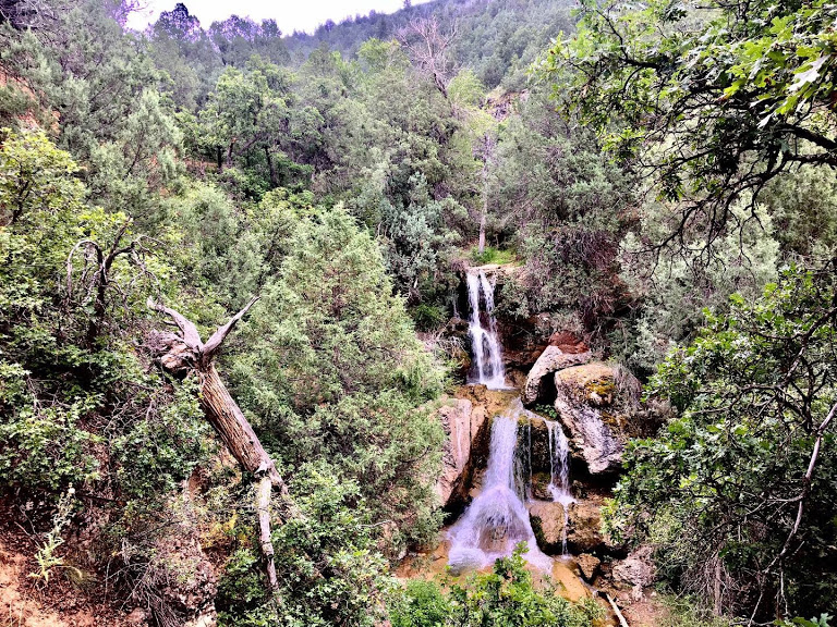
 Also known as Diamond Fork Hot Springs, this was one of the first trails I hiked when I first started hitting the trails on the regular about three years and 70 lbs ago. Other than the length, which could be daunting to the most novice hikers, Fifth Water Hot Springs is not particularly strenuous and most of the inclines are moderate and balanced out by downhill portions. The trail is used year-round, but hiking it in winter more than doubles the length because the road up to the trailhead is closed and covered in snow and ice (I've never hiked it in winter). It's also very popular, so you'll probably never have the trail all to yourself (personally, since I almost always hike alone, I prefer a moderately trafficked trail in case of incidents), but since the trail is still a reasonable length and many hikers stay to soak in the hot springs at the end, the trail itself rarely feels crowded. That said, don't even think about trying to go on Cinco de Mayo.
 Fifth Water Hot Springs is especially fun during light rain or just after rain as most of the trail runs along the lushly forested hillsides overlooking Fifth Water Creek, and in the right circumstances, the small canyon becomes lightly shrouded in mist, and with the water dripping from the many green leaves (contrasted with the red dirt trail), I can't help but think of equatorial rainforests. As you near the springs, the creek turns a beautifully opaque aquamarine and the air starts to smell like farts. I've never soaked in the springs myself (sometimes I'll put my feet or hands in and just enjoy the warmth), but I suppose if you're bold enough, there's no rule against hopping in one (there's a handful of them that have been fashioned into naturally-sourced hot tubs) with the half dozen strange people already in. A little bit past the initial cluster of hot springs with the not entirely natural waterfall (like well-done butt implants though, still beautiful), a little more hidden by the trees are more hot springs where people sometimes soak nude, but if you're hoping to peep some eye candy, it's almost it's almost exclusively the same old, fat men who are also the most confidently naked in locker rooms for some reason. There always seems to be a pair or two of Calvin Klein underwear lying in the dirt somewhere along this trail though, so go figure. However, it is worth it to continue past the main cluster of hot springs though, because just a little further up is where you'll find the best waterfall.
 SQUAW PEAK
Length: About 7 miles round trip
Location: Rock Canyon, Provo, Utah County
Highlight Features: Multiple Waterfalls, Lush Forestation, Hot Springs
How to Get There: Begin at the Rock Canyon Trailhead just west of the LDS Provo Temple (the original white one, not the rebuilt tabernacle on University Avenue) on 1060 East in Provo. To get to the actual Squaw Peak trail, you'll hike up Rock Canyon on what begins as an narrow asphalt road and turns into wide dirt path. Before the turn-off for Squaw Peak, the Rock Canyon trail crosses five different bridges, and about a quarter-mile after the fifth bridge, there's a turn-off that is sometimes slightly hidden by the trees and is marked by a boulder with very faded writing that reads SQUAW PEAK TRAIL.
 The somewhat controversially named Squaw Peak is tied to historical fact and legend set in 1850, when Mormon pioneers exterminated the independent Timpanogos people from the Utah Valley. The Battle at Fort Utah, as it's sometimes known, is historical fact in which the Mormon militia, known as the Nauvoo Legion, carried out Special Order No. 2, which kill all the indigenous men in the valley and take the "well-behaved" women and youths captive. Following the initial skirmishes, some of the surviving people of the leader Old Elk's village fled into Rock Canyon. According to local legend, after Old Elk's body was found in the canyon and beheaded, having died from measles, his wife was pursued by militiamen up into the mountains and cast herself off this peak rather than let herself be captured. American Indian women were commonly and often derogatively called "squaws" during that time period, coming from the Algonquin word for woman that was integrated into English in the days of English colonies.
The trail is quite strenuous in portions, with a particularly steep stretch soon after the trail turns off from the main Rock Canyon trail, but it's simpler and less intimidating than many of Utah's major mountain peaks, with rewards just as good. After a long, steep stretch up the backside of the mountain, the trail levels out some while crossing a couple of open meadows and providing spectacular views of the surrounding mountains and canyons. In the spring, these meadows are replete with colorful wildflowers, but if you wait too long, a lot of them dry up in the late spring-early summer heat. Later in the year, the surrounding fall colors all the way up this trail are too die for. Speaking of dying, the views of the Utah Valley at the peak are utterly spectacular, but don't get stupid. There are relatively safe spots to enjoy the view from and get some great pictures, and you don't need to stand with your toes on the very edge or climb out onto some of the more precariously perched rocks to appreciate it. People do fall from up there, and they do die down there. Like one woman told me while I was on my way up, "The peak? That's treacherous, dude!"
 GRANDSTAFF CANYON
Length: About 4.3 miles round trip
Location: Moab, Grand County
Highlight Features: Natural Arch, Creek, Sandstone Cliffs
How to Get There: Driving south into Moab on US-191, turn east onto UT-128 at the Lions Park on the south side of the Colorado River. Follow that road for a few miles until you see the sign for Grandstaff Trail.
 It isn't that Grandstaff Trail is an unknown gem or a local secret, because it isn't (it's actually fairly popular), but in an area famous for its national parks and iconic vistas like Dead Horse Point, Delicate Arch and Mesa Arch, Grandstaff Canyon goes somewhat under-recognized. As with a lot of my favorite trails, Grandstaff is accompanied by a water feature in the form of a trickling stream that accompanies the path all the way up to Morning Glory Arch at the end. Like Fifth Water Hot Springs, Grandstaff is a decent length, but without particularly steep inclines or otherwise overly difficult portions, and still satisfies an adventurous spirit, if not adrenaline junkies. The trail is lined in many spots with purple-hued cacti and crosses the stream several times via rock-hopping that might be tricky for less agile or balanced hikers, but the water isn't deep or fast enough to do any more than get you wet (I suppose you could slip and bust open your brains on one of the rocks though). Guarded by towering red rock walls for some stretches as well, Grandstaff is one of the more temperate trails in the Moab area. At the end, you're rewarded with an alright arch (it's not too high on the list of must-see arches in Utah, but it's good) known as Morning Glory Arch (I remember reading in a newspaper once that a "morning glory" was a slang term for an erection you wake up with, but I've never heard it called that anywhere else; I think most people refer to that as "morning wood"). The arch hangs over a grotto where the stream pours through a crevice in the rock, making the perfect shady spot to relax before hiking back.
The name Grandstaff refers to a mixed-race cowboy (part black, part American Indian) named William "Bill" Grandstaff who ranched cattle in the canyon in the 1870s until he was blamed for causing trouble among the Indians by supplying them with whiskey, forcing him to flee the area for his own safety. Until only a few years ago, the trail and the canyon were known as "Negro Bill Canyon." Fortunately, when people became uncomfortable with this not necessarily offensive, but certainly archaic name (which was itself a civilized improvement on the name "Nigger Bill Canyon," used prior to the 1960s), the powers that be had another name to apply that still recognized the man tied to the canyon's history.
 PARRISH CANYON & PARRISH CREEK
Length: Parrish Canyon is about 4 miles round trip, Parrish Creek is about 1 mile round trip
Location: Centerville, Davis County
Highlight Features: Wildflowers, Waterfall, Rock Art, Overlook
How to Get There: You can get right onto Parrish Lane from I-15 at exit 319, and you just follow that east until you reach the Parrish Reservoir and turn left toward the parking lot.
 I've only hiked this trail once, but it salvaged what was turning out to be a very frustrating day of wanting to hike and finding a lightning storm everywhere I went. I don't remember exactly how I settled on Parrish Canyon that day, but I know that for some reason, even while I could see big, dark rain clouds to the north and to the south, the sun was shining over Parrish Canyon. I shit you not, the hills were covered with beautiful bunches of colorful wildflowers soaking up the warm sunlight while fluffy brown bunnies hopped about, plus I found three $5 bills nestled in a sagebrush. That alone is enough to earn it a place here. Some people might say that's trying too hard, but good God. It's also a trail that is heavy on the switchbacks, going up the face of the mountain, which is something I love a lot, and there are spectacular views of Centerville, Farmington, Bountiful and the Great Salt Lake. Turning north early on the trail and crossing the red bridge to the north side of Parrish Creek will take you to a rare sight for this part of Utah. There's quite a lot of American Indian rock art throughout Utah that ranges from thousands of years old to the frontier era, but unless you know exactly what you're looking for, outside of many clearly marked sites in Southern Utah's deserts, my personal experience is that it can be extremely difficult to find. Because of legitimate concerns toward theft and vandals, many people who know the location of these rock art sites keep them a closely guarded secret, but the rock art along Parrish Creek is fairly well known and easy to find. A narrow pathway that runs alongside the creek (which is potentially dangerous during the spring when the creek is very full) for about half a mile leads to a small waterfall, and on the rocks above, you can see pictographs (petroglyphs are carved into the rock, pictographs are painted, and the latter is considerably rarer along the Wasatch) painted in red.
 BULLION FALLS
Length: About 2 miles round trip
Location: Bullion Canyon, Marysvale, Piute County
Highlight Features: Waterfalls, Historical Artifacts
How to Get There: At the tiny town of Marysvale (about 30 miles south of Richfield), head west on Bullion Avenue and turn left at the sign for Miner's Park and Bullion Canyon Road. Take this road up into the canyon where the pavement changes to dirt, and park at the end of the road, just over the bridge in Miner's Park. Walk back across the bridge to get to the trailhead that follows alongside the creek.
 Unless you opt to continue past Bullion Falls for a couple miles to see more of the mountains (which I guess you could, but eh) or climb the ropes down to the bottom of the falls (which you should because it's awesome), Bullion Falls is another trail that isn't particularly challenging, however, the scenery in the Tushar Mountains, culminating in the 75-foot waterfall, is fantastic. Fans of beef and/or chicken bullion will be disappointed though, since canyon's name actually refers to gold that was once found there, and there's little to no beef or chicken bullion to be found. Along the mostly straight trail through the canyon is the occasional abandoned miner's cabin, testifying to the area's sporadic mining booms in the 19th and early 20th centuries when gold and other precious metals were found there.
 WATERFALL CANYON
Length: About 2.5 miles round trip
Location: Ogden, Weber County
Highlight Features: Waterfall, Overlook
How to Get There: Go east on 29th Street in Ogden all the way to the end, where you'll find parking for multiple trails. Hike up to the Bonneville Shoreline Trail and turn south until you see signs for Waterfall Canyon and the trail turns to accompany the stream.
 In all honesty, Waterfall Canyon isn't one of the prettier canyons in Utah. It's somewhat similar to Battle Creek Canyon in Pleasant Grove, but dinkier. The views of Ogden and the Great Salt Lake from the Bonneville Shoreline Trail that connects to the canyon trail are beautiful though, and the waterfall itself is awe-inspiring. Tumbling 200 feet down the rocks, it's only a third as high as Bridal Veil Falls in Provo Canyon, but you can stand closer here, right in the mist, and really soak in its power. It's a worthy reward to the quadriceps-burning climb up the consistently steep and often very rocky canyon, and it's a good thing it is, because damn those rocks.
FIFTH WATER HOT SPRINGS
Length: 4.5 miles round trip
Location: Diamond Fork Canyon, Utah County
How to Get There: Take US Route 6 East from Spanish Fork for about 11 miles toward Price and turn left at the sign for Diamond Fork Road. Follow the road for about 10 miles (as you get closer, the road will narrow) until you reach the parking lot for Three Forks Trailhead on the right. Except on the busiest weekends, you can usually find a space to park, but parking on the main road is strictly prohibited. Fifth Water Hot Springs is the main trail forward (without the bridge) from the bathrooms (which smell godawful, by the way).
Length: About 7 miles round trip
Location: Rock Canyon, Provo, Utah County
Highlight Features: Multiple Waterfalls, Lush Forestation, Hot Springs
How to Get There: Begin at the Rock Canyon Trailhead just west of the LDS Provo Temple (the original white one, not the rebuilt tabernacle on University Avenue) on 1060 East in Provo. To get to the actual Squaw Peak trail, you'll hike up Rock Canyon on what begins as an narrow asphalt road and turns into wide dirt path. Before the turn-off for Squaw Peak, the Rock Canyon trail crosses five different bridges, and about a quarter-mile after the fifth bridge, there's a turn-off that is sometimes slightly hidden by the trees and is marked by a boulder with very faded writing that reads SQUAW PEAK TRAIL.
The trail is quite strenuous in portions, with a particularly steep stretch soon after the trail turns off from the main Rock Canyon trail, but it's simpler and less intimidating than many of Utah's major mountain peaks, with rewards just as good. After a long, steep stretch up the backside of the mountain, the trail levels out some while crossing a couple of open meadows and providing spectacular views of the surrounding mountains and canyons. In the spring, these meadows are replete with colorful wildflowers, but if you wait too long, a lot of them dry up in the late spring-early summer heat. Later in the year, the surrounding fall colors all the way up this trail are too die for. Speaking of dying, the views of the Utah Valley at the peak are utterly spectacular, but don't get stupid. There are relatively safe spots to enjoy the view from and get some great pictures, and you don't need to stand with your toes on the very edge or climb out onto some of the more precariously perched rocks to appreciate it. People do fall from up there, and they do die down there. Like one woman told me while I was on my way up, "The peak? That's treacherous, dude!"
Length: About 4.3 miles round trip
Location: Moab, Grand County
Highlight Features: Natural Arch, Creek, Sandstone Cliffs
How to Get There: Driving south into Moab on US-191, turn east onto UT-128 at the Lions Park on the south side of the Colorado River. Follow that road for a few miles until you see the sign for Grandstaff Trail.
The name Grandstaff refers to a mixed-race cowboy (part black, part American Indian) named William "Bill" Grandstaff who ranched cattle in the canyon in the 1870s until he was blamed for causing trouble among the Indians by supplying them with whiskey, forcing him to flee the area for his own safety. Until only a few years ago, the trail and the canyon were known as "Negro Bill Canyon." Fortunately, when people became uncomfortable with this not necessarily offensive, but certainly archaic name (which was itself a civilized improvement on the name "Nigger Bill Canyon," used prior to the 1960s), the powers that be had another name to apply that still recognized the man tied to the canyon's history.
Length: Parrish Canyon is about 4 miles round trip, Parrish Creek is about 1 mile round trip
Location: Centerville, Davis County
Highlight Features: Wildflowers, Waterfall, Rock Art, Overlook
How to Get There: You can get right onto Parrish Lane from I-15 at exit 319, and you just follow that east until you reach the Parrish Reservoir and turn left toward the parking lot.
Length: About 2 miles round trip
Location: Bullion Canyon, Marysvale, Piute County
Highlight Features: Waterfalls, Historical Artifacts
How to Get There: At the tiny town of Marysvale (about 30 miles south of Richfield), head west on Bullion Avenue and turn left at the sign for Miner's Park and Bullion Canyon Road. Take this road up into the canyon where the pavement changes to dirt, and park at the end of the road, just over the bridge in Miner's Park. Walk back across the bridge to get to the trailhead that follows alongside the creek.
Length: About 2.5 miles round trip
Location: Ogden, Weber County
Highlight Features: Waterfall, Overlook
How to Get There: Go east on 29th Street in Ogden all the way to the end, where you'll find parking for multiple trails. Hike up to the Bonneville Shoreline Trail and turn south until you see signs for Waterfall Canyon and the trail turns to accompany the stream.


Comments
Post a Comment